Beach Profiles or Transects

Beaches and dunes are in constant motion, continually changing shape and shifting position in response to winds, waves, tides, relative sea level, and human activities.
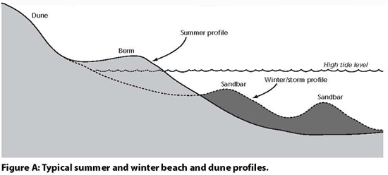
The most significant changes occur seasonally and following storms. During summer, beaches are generally higher and sandier than they are in winter. During the winter, the ‘missing’ sand moves from the beach to nearshore areas to form sandbars. This happens as a result of changing wave shape due to more intense storm activity. During spring and early summer, or following a storm, the sand in the nearshore region moves back toward -- and eventually attaches to -- the beach. Once on the beach, the finer sand grains are moved by wind action to form higher, wider sand dunes. These seasonal and storm-related interactions and changes in the form, volume, and position of beaches, dunes, and nearshore areas produce what is known as ‘dynamic equilibrium’ (Figure A, below).

Beach and dune profiling is one way to obtain information about seasonal and storm-induced beach and dune shapes. Comparing season-to-season profiles and profiles taken before and after a significant storm clearly illustrates the important changes taking place along the shoreline and how quickly coastal landforms change.

CLICK here for more on Beach transects
Beach profile animation SUMMER / WINTER
Beach profile animation Storm effects
NOAA ADVANCED GLOSSARY
Barrier Island Environments
There are numerous distinct environments found within any particular barrier island. Although one or more of these environments may be present for any given barrier island, the overall scheme appear
s both consistent and predictable. Taken in sequential order, and beginning from open ocean to the outermost reaches of the back-barrier, these environments are as follows: nearshore, beach, dune, washover fan, marsh, tidal flat, and the adjacent estuary/lagoon.

Beach
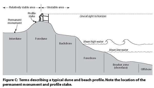
The beach, or visible portion of the profile, is the most familiar of the barrier island environments, and in many respects is the most important because it affords protection from wave attack to the landward upland environments (where development is typically located). The beach extends from the shoreline landward, and often includes numerous changes in topography such as sand dunes, sea walls, or other man made structures. A beach is typically divided into the seaward sloping foreshore and the nearly horizontal backshore.
The foreshore is considered to be that area where the last vestiges of waves rush up and back. This constitutes what is referred to as the swash zone, although such wave action can often cover an entire foreshore. This area is also the zone of the intertidal portion of the beach and may range in width depending upon slope or gradient.
The backshore is generally dry except during the occurrence of severe storms and their associated storm tides. Under normal conditions, the backshore is subjected only to wind action that blows the dry sand landward, creating dunes. Opportunistic dune or beach vegetation may occupy this portion of the beach.
Storms can cause a beach to erode, and can result in a uniformly seaward-sloping beach. This typically occurs during the winter months. During the calmer summer months, the beach gradually accumulates sediment as the result of currents, produced by low waves that r eturn sand landward to the foreshore, or emergent, portion of the profile. If there is long-term erosion of a beach, it may be due to a variety of phenomena, including storms, high rates of sea level rise, interruptions in the longshore transport system along the beach, or inappropriate construction practices along the shoreline area that function to interrupt the longshore movement of sand.

See student experiments at SWASHBUCKLERS