Sunday, October 25, 2009

The Home Environment: We have some issues

HOME
HOUSE RULES

All matter is limited, finite.
All matter begins with a star - like energy.
All “usable” energy begins with a star - like matter.
Both matter and energy can be resources.
What does the word “ Re – source” - mean?
Nature recycles naturally
What does the word “Re - cycle” mean?
Why / how are resources limited ? limited resources

All matter recycles (Law of Conservation of mass/matter)
Whether we want it to or not
Whether it’s “good” or “bad” is a human judgment
Some cycles take a long time (rock cycle animated)
Some cycles can happen overnight (H2O cycle animated)
Humankind interacts with these cycles in some way – directly or indirectly.
2 ways to Calculate your interactions. Simple (suggested) Complex

It takes energy to do anything
It takes energy to do everything
Energy recycles ! (Law of Conservation of Energy)
Energy is originally “solar” – in some form
Solar Energy “arrives” at Earth at a “constant rate,” the Solar Constant
Energy can be stored


Energy loses “usability” when changing forms.
What is entropy ? (a bit complicated)
Every energy expenditure has a cost.
Use it AND lose it.
The energy “cycle” can be simple, complex or beyond humankind time-scale.

Humankind may increase, decrease, or have no effect on the amount or rate of a cycle.
Humankind interacting with a cycle may be positive, negative, or neutral.

Science, is a process that observes, measures, models and tests the cycle(s), the biosphere and our interactions. Scientists look for patterns, and changes in patterns in order to make predictions.

If ___________________________,
(Increase, decrease, stay the same)

then _________________________ .
(Increase, decrease, stay the same)


Search and locate an issue most important to you. These are simply good starting points, jumping off points into some very deep waters ...... but you can do it.

After all, it is the only home we have.

A quick refresher, What's it all about?

A broad overview of many environmental issues, resources, and documentation try

Environmental Literacy Council
Click on their Site Map at the top of the page FOR A VERY LONG LIST of topics and issues or
Start by clicking of the MAin headings on the left side of the page.

GREENPEACE's What We Do Page

Carbon dioxide in the atmosphere (animation 1) (animation 2)
© 2009 Annenberg Media.
Air pollution
Ocean surface temperatures (animation1)
Tropical deforestation
Landfills and "Stuff"
Ogallala Aquifer
Oil depletion (5 predictions)
Ozone pollution Ozone2 Ozone animation
Electricity
The Solar Constant ( what if.. ?)

Off shore Oil Drilling ( see previous Blog: Slick Oil)


Overfishing New Overfishing site 1
Polar ice caps (melting)
Pesticides (a cycle) ground water pollution
Population (complex)
Recycling
Nuclear power
Species Diversity
Urban sprawl
The Nitrogen Cycle
Potassium (cycle) and Phosphorus (cycle) SOIL
Carbon cycle (animation 1)
Freshwater and water pollution


Other ........... ?


These are just some of the issues facing the Biosphere (of which you are a part).
Will you let others determine, define, and deal with these issues for their own interests, or will you take part for your interests? Your understanding, or lack of it, about how science works will make a big difference in the future of the biosphere – for better or for worse.


The comments box is open.

What issue are you most interested in?


What is your If...Then... Prediction?


What more would you like to know?

Monday, October 19, 2009

ALIENS INVADE !!!!

Lionfish Invade U.S. WATERS

from: The Lionfish Invasion! National Ocean Service. NOAA. revised March 2008


Local divers off the coast of North Carolina were not expecting to see what they found one day in August 2002--the exotic and beautiful lionfish, common to the warm waters of the western Pacific, but unknown at that time as residents of the Carolina coast. They provided the first solid evidence that lionfish were in the Atlantic--an actual specimen that they collected. A year later, scientists had documented 19 lionfish sightings at eight locations along the North Carolina continental shelf. By then, lionfish were also being observed off the coasts of Florida, Georgia, and South Carolina. Juvenile lionfish were also showing up off Bermuda and even as far north as Long Island, New York! Since then, many more United States divers have reported sightings of the distinctive fish. Between 2000 and 2003, 49 lionfish sightings were reported at 16 different shipwrecks and natural hard bottom locations. During a summer 2004 research expedition, NOAA scientists collected 155 lionfish at 19 different locations off the North Carolina coast alone. The jump in numbers and distribution over such a short time, plus sightings of juveniles smaller than those sold for aquaria, strongly indicate that the lionfish is reproducing in the Atlantic Ocean. If this is true, it's the first time that a western Pacific fish has populated the waters of the U.S. Atlantic coast.


How did lionfish get into the Atlantic Ocean ?

Reportedly, six lionfish were accidentally released in Biscayne Bay, Florida, when a beachside aquarium or nursery broke open during Hurricane Andrew in 1992. It's likely that even more have been released on purpose when people no longer want them as aquarium pets because they grew too large for the 
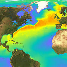
aquarium, or they learned the hard way that lionfish will eat their other fish! The swift and warm Gulf Stream, which likely transported buoyant lionfish eggs and larvae from Florida northward, helped the lionfish's Atlantic journey.


The red and black dots are locations in the Atlantic Ocean where lionfish have been reported as of May 2003. Notice that sightings are few north of Ca
pe Hatteras. Because lionfish are normally found in subtropical and tropical waters, their distribution is limited in the Atlantic by the colder temperate waters north of Cape Hatteras, where the warm Gulf Stream flows away from the continental shelf. (Photo credit: Paula Whitfield)

However, from north Florida upward, the waters along the coastline are too cold in the winter for lionfish to survive. Scientists expect them to survive the winter only at water depths greater than 120 ft because this is where the Gulf Stream has influence all year long. Very importantly, the types of predators and competitors present in the marine community in the Atlantic are very different from the native range of the lionfish. These are a couple of the reasons why scientists are paying so much attention to the lionfish invasion. Generally, species like the lionfish have not been perceived to pose a significant threat to marine ecosystems because they were not likely to survive long. Research on this topic has been minimal, however, so it is hard for scientists to answer questions such as:

It's pretty unusual for non-native, tropical marine fishes, like the lionfish, to establish themselves at this latitude. In Florida waters and along the continental shelf near the Gulf Stream the temperatures are very similar to the lionfish's native waters.


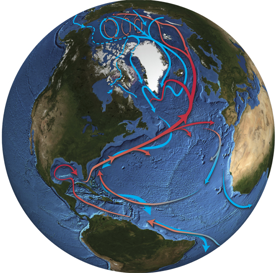
The warm Gulf Stream current (in red) may have dispersed lionfish as far as North Carolina and Bermuda, where water temperature is similar to their native habitat. Lionfish larvae may have been carried in the Gulf Stream to the northeast in a similar wa


For now, reef communities in the western Atlantic Ocean are unlikely to be in much danger, since the number of lionfish is still relatively small. If the population grows large, though, lionfish could damage the native ecosystems. At the same time, other factors are already causing stress to these ecosystems, and these stress factors or "stressors" tend to favor the lionfish's expansion.

Lionfish also are believed to pose particular risks to the local environment. They are hungry predators that feed on practically anything that swims. They can easily devour the young of important commercial fish species, such as snapper, grouper and sea bass, many of which use the region's "live bottom" reefs as nursery grounds. Lionfish are ambush predators and may use their outstretched, fan-like pectoral fins to "corner" their prey. They don't sting their prey, though. Their venomous spines are used mostly for defense. Scientists are concerned that lionfish could seriously reduce the numbers of prey species and/or compete with other reef predators. When a new species is introduced in an area, it can take over the niche, or role, of a native species in its ecosystem, thus squeezing it out--this process is called competition. Another important factor is that native prey species lack of experience in confronting the intimidating lionfish might make the lionfish a more effective predator.

Is the Aquarium Trade to Blame?

The aquarium trade appears the most likely vector for the introduction of lionfish into U.S. waters, but the lionfish's introduction into the Atlantic remains something of a mystery. Recent research indicates that a number of other tropical aquarium fish are currently surviving off the coast of Florida. Also, the color patterns of lionfish sighted off the Atlantic coast of the U.S. are similar to those from the Philippines, where many lionfish are collected for the aquarium trade.

In Europe imports of a wide range of popular wild-caught tropical fish have been restricted of banned in 2008 Import Directive. All European Union Member sgtates and some members of the European Economic Union including Norway were required to put regul;ations in place to implement this directive by May 2008. The United States is considering similar bans on aquarium fish imports.

Scientists say it is impossible to determine if the lionfish released in 1992 account for the species invasion of Atlantic Ocean. Some scientists have suggested that lionfish entered Atlantic waters when larvae or juvenile fish were trapped in ships moving from the Pacific to the Atlantic and were released when the ballast water was pumped out.

However, there is no evidence to support ballast water as the source for the lionfish invasion, although it is a common source of aquatic alien species introductions generally. Further, although lionfish have been introduced into the western Mediterranean, probably through the Suez Canal, there is no evidence that they crossed the Atlantic or that they entered the Atlantic through the Panama Canal. Besides, it is very unlikely that the tropical lionfish could survive a journey across the cold water between the two oceans. (http://oceanservice.noaa.gov/education/stories/lionfish/lion03_blame.html)


Another Juliane link suggestion right HERE. ALIENS EVERYWHERE !!!!

Sunday, October 18, 2009

It's not simply global warming... IT's CLIMATE CHANGE


Does Earth's climate system have an 'Achilles' heel'?

Here is a simplified description of some basic ocean-atmosphere dynamics that regulate Earth’s climate:

The equatorial sun warms the ocean surface and enhances evaporation in the tropics. This leaves the tropical ocean saltier. The Gulf Stream, a limb of the Ocean Conveyor, carries an enormous volume of heat-laden, salty water up the East Coast of the United States, and then northeast toward Europe.


Two views of the Gulf Stream
--------->


The global ocean is not a static pond, but a body in constant motion. Winds blow across its surface, generating waves and currents, while the pull of gravity gently sloshes it back and forth in a lunar rhythm of tides. But beneath these familiar surface motions is a seemingly mysterious process which has major implications for Earth's climate: the Great Ocean Conveyor (also called the thermohaline circulation).


The Conveyor is one of the great unknowns in humanity's unintentional climate change experiment. Surface water, warmed at the equator, moves to high latitudes where it releases heat to the atmosphere. As a result, the water cools - becoming denser - and sinks to the deep ocean. Deep water slowly travels through the oceanic abyss, eventually mixing up to the surface in distant parts the world, as much as 1000 years later.

This oceanic heat pump, is an all important mechanism for reducing equator-to-pole temperature differences. It moderates Earth’s climate, particularly in the North Atlantic region. Conveyor circulation increases the northward transport of warmer waters in the Gulf Stream by about 50 percent. At colder northern latitudes, the ocean releases this heat to the atmosphere—especially in winter when the atmosphere is colder than the ocean. The Conveyor warms North Atlantic regions by as much as 5° Celsius and significantly moderates average winter temperatures.


The transfer of energy, heat, by the great Ocean Conveyor is what lets Norway, which is as far north as Manitoba Canada have annual temperatures 20 degrees warmer. If not for the North Atlantic loop of the Conveyor, European winters would be much colder. London would be like Laborador, Berlin might have the climate of Edmonton Alberta, which lies at the same latitude, while Stockholm might be more like Nome, Alaska.

(CBS/AP) OCT 16, 2009
The North Pole will turn into an open sea during summer within a decade, according to data released by a team of explorers who trekked through the Arctic for three months.

NBC Nightly News Channel - Oct. 15, 2009
The Arctic Ocean will be an "open sea" almost entirely free from ice within just t
en years. Ice over during the summer months will have entirely disappeared within 20 years, but most of the decrease will happen before 2020.


So Santa needs a new home ... What else?

Unfortunately it may get even more confusing...


More like

Out of the frying pan and in to the freezer ?


In 2005 Nature , published the results of a study showing that the Gulf Stream current (the one that keeps Europe warm despite the fact that the UK is as far north as Hudson Bay) has slowed down by about 30% since 1957. The study noted that the slowing has mostly happened in the years since 1998.

Further studies indicate that during that time due to all the fresh water runoff from melting ice, North Atlantic waters have become steadily less salty in the places where cold, salty water is supposed to sink, starting the Great Conveyor. Fresher water is less dense than ocean water and does not sink as readily. The Great Conveyor is slowing down.


Records and evidence of past climates—from deep-sea sediments and ice-sheet cores—show that the Conveyor has slowed and shut down several times in the distant past. This shutdown stopped the heat transfer to the North Atlantic and brought about colder climates and mini -Ice Ages. One earth scientist has called the Conveyor “the Achilles’ heel of our climate system.” (Gagosian, Robert B. Woods Hole Oceanographic Institution updatedSeptember 3, 2009)

Something is throwing the climate out of balance. Computer models and scientists agree that it appears to be human activity and increased greenhouse gasses. The warming and freshening (i.e. reduced saltiness) in the northern North Atlantic ocean predicts a slowing or even a complete stop of the North Atlantic currents - just like the sudden cooling in the past, thousands of years ago.

This could be disastrous for eastern North America and western Europe. Average temperatures could plunge by 5 degrees C - for comparison, this is about the same difference as between the global average temperature today and during the last Ice Age, when Canada lay beneath 3000m thick glaciers. (David Suzuki Foundation, 2009)


So..

The Comments Box is open..


What do you think?


How can people help change what could happen?


What more would you like to learn?

Sunday, October 11, 2009

Sands of Time

The Florida plateau, that part of the Earth that holds Florida up out of the ocean ... at least for the moment ... was formed just 530 million years ago. As well as being much larger in the distant past, it wasn't really recognizable as FLORIDA until between four and six thousand years ago. Then you would have found it familiar... bays, estuaries, Everglades, and of course, beaches.

Florida Beaches are a treasure in sand. It is a matter of perspective we don't truly understand while we remain Earthbound. Even from space it is difficult to grasp.

It is a rare day when the entire coastline of the southeastern United States is cloud free at the same moment. January 9, 2009 was nearly such a day, and, from the perspective of the MODIS instrument on the Aqua satellite, the ocean also happened to be sunglint free at the same time.


We often take our beaches for granted, though: Before you curl your toes into the warm beach sand or run splashing into the water, take a moment to partake in the wonderful world of coastal formation! Coastal formation occurs on several scales, ranging from the motions of the planets all the way down to the interactions of molecules of water.

On the largest scale, coastlines are formed from two processes: coastal emergence and coastal submergence. Coastal emergence happens when land emerges out of the water. This can occur, for example, when a mountain range at a plate boundary is uplifted. Imagine the coastline of Chile, closely paralleled with the Andes Mountains. Millions of years ago the Andes were pushed up from the crust, forming a new coastline.

Far more coastlines, however, have been formed by submergence. Coastal submergence occurs when the water level of the ocean rises significantly, flooding formerly inland regions. The entire east coast of the U.S., for example, is a coast of submergence. The majority of today's coastlines are of this type because of the rise in sea level following the last Ice Age.

There are many ways that coastlines are continually changing...Coastal Processes


Beach formation on a more familiar scale deals with actual aggregate movement- SAND. Put simply, the Sand Man's day job is to shovel beach sand, a lot of beach sand. The movement of beach sand happens in two ways. The movement of sand perpendicular to the beach and the movement of sand along the beach. Both are caused by a combination of wave motion water currents, and wind. Wave motion animation.

Sand movement toward and away from a beach is dependent largely on the TYPE OF WAVE. Waves known as spilling breakers, or constructive waves that surge water up on the beach, depositing sand and dissipating the wave's energy. A Plunging breaker, or destructive wave, tends to collapse in on itself, sucking sand away from the beach in a backwash and contributing energy to the following wave.

Currents also have a significant effect on the movement of sand in and out from the beach. If waves are responsible for the movement of sand on and off the beach, then currents are responsible for the movement of sand to and from the waves. Beaches are always on the move! Check out the SWASH?

Imagine a grain of sand being taken away from the beach. As this grain is swirled about in a tempestuous fury of foam and churning water, it is eventually picked up by a current known as a rip current or rip tide. These "rip tides" funnel outward between underwater sand bars and then die out in deeper water. The grain of sand then drifts towards the sandbar, settling down until picked up once again by an incoming wave. That wave will eventually deposit the sand on the beach, repeating the cycle. Because rip tides only occur between breaks in under-water sandbars, they don't have enough force to cause a net movement of sand away from the beach.
(Thank you http://www.thetartan.org/2005)

(If you're ever stuck in a riptide, swim parallel to the beach and you'll soon escape its grasp!)


Another type of current, known as long-shore drift is responsible for the movement of sand parallel to the beach. Long-shore drift occurs because waves often strike beaches at an angle. When they do this, the waves deposit sand along one direction and pull it away on another. This tends to form a zig-zag movement of sand along the edge of the beach, pushing sand in the direction that the waves are striking. This movement is responsible for the formation of several coastal structures including spits, hooks, tombolos, and coastal bars.

This drift has important consequences for the man-made development of coastal regions. Beachfront worth billions of dollars in property value can disappear as sand slowly moves down the coast. Many coastal towns build erosion control structures along their beaches... not always with the greatest of success.

Groins, jetties, seawalls, and breakwaters are basically walls made of concrete, wood, or piles of rocks in attempts to manage the flow of sand and reduce coastal erosion. The continued over-development of coastal regions is just like building your house on a sea-side glacier. Sure, it may look stable now... but eventually it really is going slip right out from under you and fall into the sea.

It's just a matter of time.


NOTE: AN EXCELLENT REVUE OF THIS MATERIAL IS HERE !


Juliane likes this site... for longshore current


Lexi, you might be interested in the Rubber Ducky study.

The comment box is open?

What do you think?


Are we ignoring science when we build right on the beach? ..Is that a good thing?


What more would you like to know?

Tuesday, October 6, 2009

National Marine Sanctuaries

This is the doorway to the National Marine Sanctuaries .


Look for this picture at the bottom of the page. You can click on each of the sanctuaries and search.

All these places are spectacular. You should have a first and second choice, we wouldn't all want to do the same one.

When you have made your choices, write them down with a couple of reasons that led you to your decisions.


A reason why we really might need these sanctuaries.... watch this!


And where does all this end up?

Sunday, October 4, 2009

When the Ocean Floor Breaks ...

APIA, Samoa - Police in green reflective vests searched a ghastly landscape of mud-strewn streets, pulverized homes and bodies scattered in a swamp Wednesday as dazed survivors emerged from the muck and mire of an earthquake and tsunami that killed at least 119 in the South Pacific.

Military transports flew medical personnel, food, water and medicine to Samoa and American Samoa, both devastated by a tsunami triggered by an undersea earthquake. A cargo plane from New Zealand brought in a temporary morgue and a body identification team. Officials expect the death toll to rise as more areas are searched.

Survivors fled to higher ground on the islands after the magnitude 8.0 quake struck at 6:48 a.m. local time (1:48 p.m. EDT; 1748 GMT) Tuesday. The residents then were engulfed by four waves each 15 to 20 feet high that reached up to a mile inland.


The Pacific Tsunami Warning Center in Hawaii said it issued an alert, but the waves got to the islands so quickly that residents only had about 10 minutes to respond. Another system designed to alert aid agencies suffered a hardware malfunction that delayed notification, but that did not affect island residents. The waves splintered houses and left cars and boats — many battered and upside down — scattered about the coastline. Debris as small as a spoon and as large as a piece of masonry weighing several tons were strewn in the mud.
(warning system animation)

The quake was centered about 120 miles south of the islands of Samoa, which has about 220,000 people, and American Samoa, a U.S. territory of 65,000. ( AP , 2008 )


What is a tsunami?

A tsunami (pronounced tsoo-NAH-mee) is a series of waves, made in an ocean or other body of water by an earthquake, landslide, volcanic eruption, or meteorite impact. Tsunamis can cause huge destruction when they hit coastlines. Some people call tsunamis “tidal waves”, but these large waves really have little to do with tides, so the term “tidal wave” does not really suit them.

Tsunami waves are different from the waves you can usually find rolling into the coast of a lake or ocean. Those waves are made by wind offshore and are quite small compared with tsunami waves. A tsunami wave in the open ocean can be more than 100 km across. That’s roughly the length of 1000 American football fields! Tsunami waves are huge and can travel very quickly, at about 700 km/hr, but they are only about one meter high in the open ocean.

As a tsunami wave travels into the shallower water near the coast, it slows and grows in height. Even though a tsunami may be barely visible at sea, it may grow to be many meters high near the coast and have a tremendous amount of energy. When it finally reaches the coast, a tsunami may appear as a rapidly rising or falling tide or a series of waves with a maximum height of up to 30 meters.

A few minutes before a tsunami wave hits, the water near shore may move away, exposing the ocean floor. Often the first wave may not be the largest, and additional waves may arrive at the coast every 10 to 60 minutes. They move much faster than a person can run. The danger from a tsunami can last for several hours after the arrival of the first wave. Unlike other waves, tsunami waves typically do not curl and break.

Coasts affected by a tsunami will be severely eroded. A tsunami can cause flooding hundreds of meters inland. The water moves with such force that it is capable of crushing homes and other buildings. ( Gardinier, Lisa. 2008Windows to the Universe, at http://www.windows.ucar.edu/)

(before and after pictures)


One of the worst natural disasters....

On the morning of December 26, 2004, many coastal residents of northwestern Sumatra were startled as water at the shore dramatically receded below the normal low-water mark, leaving fish flapping on the exposed beach. The people drawn closer to the coast by this remarkable sight surely didn't know how to explain the water's bizarre behavior. Yet even in the early hours of the tsunami disaster, scientists began to grasp what was happening. In the following days, using maps of the seafloor and seismic data, tsunami researchers produced remarkably accurate computer simulations of the monstrous series of waves that took hundreds of thousands of lives.

Click here for an interactive view of the ANATOMY OF A TSUNAMI... the 2004 tsunami in the Indian Ocean. This is a good link to Enchanted Learning for a tsunami glossary.

Watch this video to learn about the amazing power unleashed into the ocean when the Ocean Floor breaks...


The comments box is open

What do you think?


How does this information help your understanding of the world around us?


What more would you like to know?