![]()
|
|

The ingredients for a hurricane include a pre-existing weather disturbance, warm tropical oceans, moisture, and relatively light winds aloft. If the right conditions persist long enough, they can combine to produce the violent winds, incredible waves, torrential rains, and floods we associate with this phenomenon.
Each year, an average of eleven tropical storms develop over the Atlantic Ocean, Caribbean Sea, and Gulf of Mexico. Many of these remain over the ocean and never impact the U.S. coastline. Six of these storms become hurricanes each year. In an average 3-year period, roughly five hurricanes strike the US coastline, killing approximately 50 to 100 people anywhere from Texas to Maine. Of these, two are typically "major" or "intense" hurricanes (a category 3 or higher storm on the Saffir-Simpson Hurricane Scale).
Can you AIM A HURRICANE? try here
 are severe tropical storms that
form in the southern Atlantic Ocean, Caribbean Sea, Gulf of Mexico, and in the eastern Pacific Ocean. Hurricanes gather heat and energy through contact with warm ocean waters. Evaporation from the seawater increases their power.
Hurricanes rotate in a counter-clockwise direction
around an "eye." Hurricanes have winds at least 74 miles per hour. When they come onto land, the heavy rain, strong winds and heavy waves can damage buildings, trees and cars. The heavy waves are called a storm surge. Storm surges are very dangerous and a major reason why you MUST stay away from the ocean during a hurricane warning or hurricane.
 |  |  |  |
 |  |  |
|
Storm Surge, the Coastal Killer.
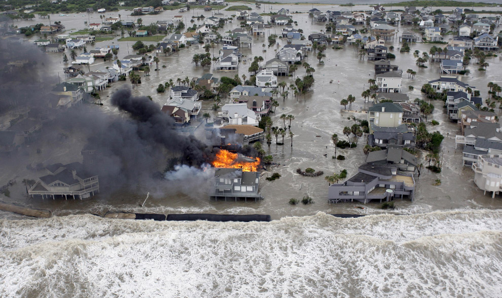

Click image to activate Storm Surge the coastal killer. For more animation click here ( Surge animation with shallow continental shelf) or here (steep continental shelf).


Surge Vulnerability Facts
(evacuation map of Pinellas County)- From 1990-2008, population density increased by 32% in Gulf coastal counties, 17% in Atlantic coastal counties, and 16% in Hawaii (U.S. Census Bureau 2010)
- Much of the United States' densely populated Atlantic and Gulf Coast coastlines lie less than 10 feet above mean sea level
- Over half of the Nation's economic productivity is located within coastal zones
- 72% of ports, 27% of major roads, and 9% of rail lines within the Gulf Coast region are at or below 4 ft elevation (CCSP, SAP 4-7)
- A storm surge of 23 ft has the ability to inundate 67% of interstates, 57% of arterials, almost half of rail miles, 29 airports, and virtually all ports in the Gulf Coast area (CCSP SAP 4-7)
Discuss the type of hazards that could affect your family. Know your home's vulnerability to storm surge, flooding and wind.
![]()
Water - at least 1 gallon daily per person for 3 to 7 days
— non-perishable packaged or canned food / juices
— foods for infants or the elderly
— snack foods
— non-electric can opener
— cooking tools / fuel
— paper plates / plastic utensils
— insurance, medical records, bank account numbers, Social Security card, etc.
— proper identification / immunization records / medications
— ample supply of food and water
— a carrier or cage
— muzzle and leash
Are you ready